Saturday, March 31, 2012
Winelands
We are now into the Winelands area on the map.
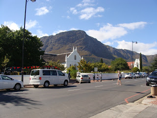
Franschoek is billed both as the food and wine capital of SA and as its most beautiful town, and it all might be true. The main street is a bit touristy with lots of arts and craft stores, real estate agencies and restaurants. The setting is phenomenal with the vineyards all around and dramatic mountains behind them. The town was settled and became a wine region due to the immigration of Huguenots (French protestants) who fled Catholic oppression in the 1600's and 1700's and brought their wine making skills to SA. On the way here we went through the Huguenot Tunnel, (3.9 km long) and at the end of main street there is a big Huguenot monument.
Our B&B host, an ex-Scottish, ex-Jo-burg business man who retired with his wife to Franschoek suggested that we try a restaurant called BOCA at the Dieu Donne Vineyards. It is up on the mountainside and overlooks the valley. We had a wonderful experience starting with champagne and tapas on the terrace then a great dinner at a table by the window inside. The pics of the mountains are taken at sunset and then in the morning from the terrace.
We also were fortunate to be here on Saturday when they have a farmers/crafts market.
In the morning we moved on to Stellenbosch, a much larger town with a university, colleges and a culinary institute. Can you imagine the happy students here! There are many wineries, a lot of them more self-contained resorts with hotels, conference centers and wedding sites. We are not that far from Cape Town and it apparently is a very attractive option to come out here for events rather than stay in the city. We had a wine tasting at one and also visited Spier Vineyards that includes a Cheetah rescue operation. Cheetahs are much more endangered than Lions or Leopards because they tend to come in conflict with farmers more. They are beautiful cats. You can pay to go in the pens and pet them, have your pictures taken with them but our timing wasn't right.
We had a very nice dinner at the Apprentice restaurant, run by the local Institute of Culinary Arts. Unfortunately we were one of only 3 tables.
Friday, March 30, 2012
Prince Albert
If you want to locate us on the blog map, we are very near Oudshoorn.
The town of Prince Albert is a little farming oasis set at the foot of the Swartberg Mountains (and our favorite pass). It reminded us a little of Mormon outposts in Utah, only it has an art scene/gay community and a real estate market that seems to be like Telluride in the early days: some interesting Victorian period architecture with gingerbread, numerous real estate offices lots of "investment opportunities" for wealthy people from Cape Town which is 4 hours away. Only problem is there is no ski area.
The Dennehof B&B where we stayed was the earliest farm in the area. It was converted to a B&B twenty years ago and now has a very sophisticated feel to it. We stayed in the Carriage Barn which had a shabby chic/southwest feel to it due to the large timber beams, thick walls and cow hide rug. Dinner at The Gallery on main street was another treat: impala for me, vegetables with a quinoa stuffing for Eva and a Malva Pudding,a kind of syrup soaked sponge cake that was billed as the SA national dessert.
From there we drove through the high dessert with straight roads, scenic mountains in the distance and lots of trucks to pass. Since a lot of highways here are only two lanes, drivers are very curteous and drive to the left in what would be the breakdown lane for us to let other drivers pass. After you pass you flash your lights to say "thank you".
We also passed more ostrich farms. The area saw a heyday in the late 1800's when ostrich feathers were used in hats, boas, etc. were fashionable. Now they have a couple ostrich farms where you can ride an ostrich (we didn't do that) or you can buy decorated ostrich eggs. I also had ostrich carpaccio for dinner one night.
Swartberg Pass
We had another google map moment. The road after Cango Caves goes through mountains and is shown as the Swartberg Pass. What we didn't realize from Google or Garmin was that it would be 30 km of narrow switchbacks on a dirt road with some pretty frightening drop offs. It is the scariest version of a public highway that I've been on. Very close to the road going up to Pandora basin in Telluride, but we were driving a tiny Ford, not a 4-wheel-drive Jeep.
The Road was built in 1888 using dry fit stone walls: no cement, no guard rails. Other than some grading upkeep after washouts I don't think it has been improved since then. They did manage a couple warning signs such as "No trailers or heavy vehicles" and "Use low gear" .
When we got to our lovely B&B in the town of Prince Albert we found out that the owners offer mountain bike tours: they take you up to the top of the pass and leave you and a friend with mountain bikes and think that it will be fun for you to ride down. Eva and I think not.
Oh, and guess what the sign says at the summit, "Die Top"!
Cango Caves
A stop on the way inland from Tsitsikama is the Cango Caves, one of the largest caves in the world. Our tour was 1 hr. and we didn't get 1/4 of the way into the cave. One chamber is so big it was used for classical concerts for 20 years until they stopped them in 1995 because of damage to the cave.
One funny building from Storms River Village advertised an Elvis Festival and had a building called the Tupulo House.
A beautiful flowering shrub in the Tsitsikama area is called "fynbosch" or literally "fine bush". Besides being a beautiful heather-like flower its name reminds me of one of the funny variations on the pronunciation of "Fine Bouche".
Thursday, March 29, 2012
Bungee
I had read in the travel books about the "Guiness Book of Records - Highest Bungee in the World" at the Bloukrans Bridge near Tsitsikamma. When we got there and looked at the bridge it was a little more scary. But they do have a 100 percent safety record and there were all sorts of young kids doing it so I thought "Why not, you'll only be here once?"
You get to the jump point in the middle of the bridge by walking out a catwalk (open grid so you can look straight down under your feet) attached under the highway. Can you imagine this being allowed in the US? Once out there there is a whole team of guys bouncing around to loud hip-hop music, giving a slightly intense but also "not to worry" feeling to the staging area: it's a party, what could go wrong? They hitch you up with pads around you ankles and you also have a harness that is a "safety" line. They help you hop up to the edge, put your toes over and count "5,4,3,2,1 Bungee" at which you spread your arms and leap. The initial fall takes about 4 seconds, then you bounce back up a couple times. A guy is lowered on a wynch who attaches a line to your harness and you are pulled up together.
Luckily, I was the second to go so I didn't have much time to think about it. One girl who wasn't sure if she wanted to do it to start with got up to the edge and couldn't jump. The guys were very good about trying to calm her down but it didn't work. Maybe she had heard about the incident at Victoria Falls where the cord broke and a woman fell. She sustained only minor injuries but she had an actual river to fall into. Here the canyon is another hundred or so feet below the full extension of the jump.
Apparently there is a higher bungee now but it is from a building so the Bloukrans jump is now relegated to being the Highest BRIDGE Jump in the World. It was fun to do this one but I'm not going to rush trying to get to the one that's the new record holder!
I seem to be having problems attaching pictures. When we get back I have more bungee pics and a video to show you.
Tsitsikamma
Tsitsikama National Park is a beautiful stretch of rocky coast with crashing waves and cabins and camp sites that sit right next to the rocks. The most famous hike in SA is the Otter Trail, a 5-day track along the coast with overnights in huts. We did the shorter half-hour walk to the suspension bridge at Storms River Mouth. Our Forest Hut was a simple log cabin tucked back into the trees. We were ready to share facilities with the campers but had a a nice surprise, a full bathroom at the back of the hut.
The wild flowers are gorgeous and they attract some awesome birds as you can see.
Wednesday, March 28, 2012
Addo 2
At Kruger we jokingly called all the massive elephant poop in the road "Kruger Speed Bumps". Here at Addo they actually have signs saying don't run over the dung or the Flightless Dung Beetles that inhabit them: turns out the beetles are an endangered species!
Then there are the ant hills. In northern Kruger they looked like drip castles and could be as much as 10 feet tall. Here they are more like a classic bee hive shape and can be up to 5 feet tall.
At the gate into Addo they have a couple of elephant skulls that are intriguing because of the honeycomb structure that you can see in the picture. I can't remember the exact function but it has something to do with their sense of smell or hearing.
We saw a lot of Warthogs, more than we saw in Kruger. Red Hartebeast is yet another variety of antelope that we saw. It name comes from its red color and the heart shape of its horns.
Finally, the monkey sitting on the wires. We wondered why he wasn't fried. He obviously knew more than we did as further down the road all the wires were down and it became evident that the power lines were no longer in use.
Addo Elephant National Park
Vanessa, our host here at the lodge, gave us a tutorial on all the kinds of antelope that they have mounted on the walls so that we could do a better job of identifying them once we were in the park. We took more corrugated dirt roads to the park where most of the roads are also dirt. Things started slowly but by the end of the morning we had seen a Black Rhino (different from the White Rhinos at Kruger), Warthogs, Kudus, Buffalo, Zebra (again a different variety than those at Kruger), Guineafowl, Egrets and a couple of lone elephants.
In the afternoon we headed further south and came across a herd of at least 40 elephants fairly close to the road. Most were grazing but the young males were challenging each other to see who would be dominant (typical male behavior). They raise their trunks and sometimes you can hear their tusks knock together. After only a couple minutes "the winner" raises his trunk, the loser lowers his trunk and backs away. We also had a single elephant come up the road to within 10 feet of the car, not minding us but intent on some of the tree tops by the side of the road.
Cars were stopped by the side of the road where there were 3 lions sleeping in the grass. Occasionally one would raise its head (see picture), yawn and go back to sleep. The female in the front was sprawled out on her back as though she wanted to sun her front side.
Heaven
We were amply rewarded for our early arrival. It is a perfectly clear day, 75 degrees with a light breeze here at the Valley Bushveld Country Lodge where we are relaxing waiting for the hot tub to warm up. As you can see by the pictures, this is no hut. And there isn't another guest here. We do have a cook and her helper who are fixing dinner. Just us and the birds, after dinner the hot tub and the stars. We feel a little bit like "Downton Abbey goes to Africa because the two of us are seated for dinner at a long table that seats fourteen. Tomorrow we will go see the elephants at Addo Elephant National Park.
I am sure you can recognize most of the stuffed heads on the walls in the lodge. Maybe you recognize the huge "corkscrew" horns of the Kudu from one of our recent "in the wild" pictures. These heads are from animals hunted on private reserves. The lodge owners breed these type of animals on their "farm" and every two years they have a round up, using a helicopter, to collect animals that are sold to the hunting reserves or parks. The hunting is very highly regulated by the government. The Giraffe had an injured hoof and was lame so the owners of the game park where it lived requested that it be"put down". The end of this week our lodge will be filled with American hunters who come over here to shoot on the private game reserves.
Kamburg
Our second excursion in the Drakenbergs was at Kamburg. "Kam" comes from the Dutch name for cocks comb, i.e., a mountain that looks like a cockscomb. To get to the park we had another teeth-chattering drive on dirt roads. The highpoint of Kamburg is a San art center. They have a video explaining the bushmen, their art and their spiritual concepts and their extinction at the hands of white settlers. One scene showed the bushmen (on foot) rustling cattle, being tracked by the settlers and being shot down. In their view, the idea of ownership (animals or land) doesn't exist. Sound exactly like the story of Native Americans.
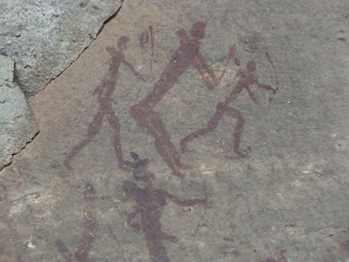
We started the 1.5 hour hike up to the caves with a young English couple. He is a pilot for British Airways and she is cabin crew, both have traveled a lot in the US and both love Boston. The paintings are so clear and well preserved that it is mind-blowing to think that they could be a thousand years old or more. They can't date them for sure but the San culture goes back 4000 years. Like the Giant's Castle caves the main figures are Eland (large antelope), San hunters and shaman (elongated human body with Eland head and hooves with smaller markings representing bees (a symbol of both auditory and somatic hallucination or contact with the "spirits". I can't say enough how powerful and stunning the experience was.
The "English pilot" had pictures of Newspaper Rock (Native American petroglyphs) on his iPhone that he showed to Raymond (our guide). Raymond makes one or two trips a day up the mountain, points out and explains the paintings and brings the visitors back down. Needless to say he was quite fit.
We had grilled tuna sandwiches and drove back out the dirt roads on the way to Umtata. Driving, especially at night, is scary. No matter how many signs they put up warning about potholes, you can't help but hit some. Then there are all the people walking beside or even in the roads that you don't see until your headlights pick them up. We were told that over half the highway fatalities in SA are pedestrians.
Our overnight in Umtata was uneventful. Since the road construction slows us down so much we decided to get on the road and skipped the Nelson Mandela museum (he is originally from that area).
Saturday, March 24, 2012
Drakensberg
From Ladysmith we drove south and west to the Drackensberg (dragon mountains) area. This is a world heritage site both because of the beauty of the mountains and the concentration of San (bushman) cave paintings. I have a great interest in the paintings because of a book (The Mind in the Cave) that explains San art alongside primitive Native American art and European cave paintings such as Lascaux and Altimira.
Ladysmith Downtown
After leaving the posh Rest lodge a the top of a hill overlooking Ladysmith we went downtown to use an ATM, get some Sudafed for Eva and buy a map (yes, we are a little frustrated by not knowing where our GPS is taking us).